Environment
Brownfields | Greenspaces
*This website is still a work in progress!
Environmental Quality and Public Health
The West End community has various natural features which have implications for overall environmental quality and human health. As part of the framework plan, this section focuses on the West End business district by building on existing strengths and maximizing the opportunities to enhance the streetscape and urban form into an integrated ecological design. In order to create a lasting urban space, it is important to understand the natural context and the forces that it exerts upon the built environment. It is just as important to have an understanding of the social needs in order for the area to thrive. Considering the natural and social forces in the framework plan will result in an effective plan to address the substantive needs of West End.
Problem Statement
The West End has many positive natural and social aspects which ought to be emphasized and celebrated, but there are many factors which should be addressed to promote the health and vitality of the community. The environmental and public health aspects discussed in this section are directly related to the other components of the comprehensive plan; they cannot be considered apart from the overall context. Accordingly, this section seeks to answer the following research question:
How can the West End integrate economic, transportation, and community development initiatives with an emphasis on ecological and social sustainability at the neighborhood level?
Ecological and social sustainability are an important component to framing this question. Sustainability in this context is defined as preserving and enhancing the functionality of existing complex systems, and to ensure their resilience into the future. Ecological sustainability refers to long-term preservation and enhancement of all plant, animal, air, water, and other natural resources which are local to the area. Social sustainability refers to the engagement of the community in decision making processes, the enhancement of the quality of life, and the preservation of the community's resilience for future generations.
In order to answer this question, it is important to understand the characteristics of the urban ecology in the West End, and its context within the broader City of Atlanta. This section will give a detailed analysis of the neighborhood's environmental considerations, reveal insights into the public health of the community, and layout a framework for civic involvement in the planning process to emphasize these important features within the overall comprehensive plan.
SWOT
Strengths
- +The residential portion of West End has good tree coverage
- +The Southwest Beltline runs along the southern boundary of the study area
- +Many parks exist throughout the neighborhood
Weaknesses
- +There are numerous brownfields in the study area and the impact areas
- +The lack of trees in the commercial district around the Mall at West End creates an urban heat island in that area and, as a walking and transportation corridor, this may decrease quality of life
- +Street lighting needs to be prevalent throughout the area to promote and improve perception of safety
Opportunities
- +Civic involvement can help shape ecological and social sustainability
- +Additional trees and vegetation could improve the quality of commercial district and decrease heat island effect
- +Covered areas could provide shade for pedestrians
- +The areas around the MARTA station could provide a good location for a farmer's market
- +Through careful analysis of slope and topography, a comprehensive stormwater plan could be enacted to reduce runoff and strain on the municipal water treatment system
Threats
- +Environmental remediation may be cost prohibitive and deter development or redevelopment
- +The heat island effect and lack of greenspace could negatively affect quality of life
- +Environmental quality and public health improvements are critically dependent on community participation and support
Ecological and Social Solutions and Means
Watersheds
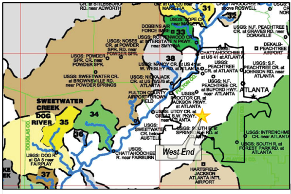
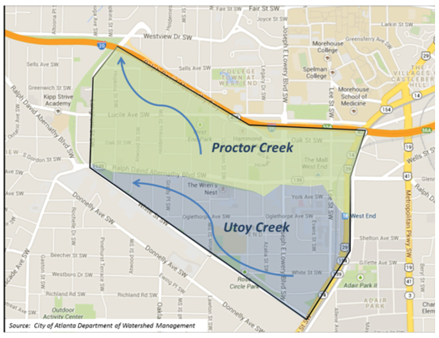
The West End consists of two tributaries of the Chattahoochee Watershed. The Proctor Creek Watershed originates in Western Downtown Atlanta, with the Southern boundary extending into the Northern portion of West End above Oak Street. The Utoy Creek Watershed originates at Metropolitan Boulevard and permeates North and Westward into the remainder of the West End residential neighborhoods and the commercial district. Biological, chemical, and storm water runoff are significant concerns for both the immediate West End community and the broader Atlanta region. These problems can have a significant impact on the ecological and social sustainability of the neighborhood, which can also result in further disinvestment and population outmigration.
Map of Atlanta Area Watersheds
Proctor & Utoy Creek watershed flow in the West End
Regulating storm water runoff into these delicate watershed systems requires an active interest by the City of Atlanta. Many residents have voiced concern that industrial brownfields and construction sites allow unknown quantities of chemicals, refuse, and heavy metals into the watershed. The City of Atlanta has several programs in place to combat these problems, including greenspace protection, streambank stabilization, flood prevention, land development regulation, and storm sewer infrastructure maintenance. (City of Atlanta) Concerned citizens do not have the resources or authority on their own to enforce proper waste disposal away from the watershed. The NPU-T meetings serve as a forum to raise awareness of these problems, but when the city's programs are not a priority, these issues will persist.
It is recommended that the West End community leaders continue to engage the NPU-T, and form an alliance with the Metropolitan North Georgia Water Planning District (MNGWPD). MNGWPD is committed to preserving and enhancing the water resources of the city, and can provide the West End useful tools to assist in watershed protection. According to their website,
Community leaders can find a wide variety of tools and resources to map out a community-level watershed management plan for the neighborhood. West End residents, with adequate support from the City, can promote the proper disposal of waste and chemicals, stormwater runoff control measures, and remediation procedures that can improve the quality of the area's water resources. Additionally residents are more likely to support initiatives that originate from local leadership.
Vegetation & Permeability
The single-family residential neighborhoods, encompassing the majority of the West End Historic District to the North and South of Ralph David Abernathy Blvd., have rich tree density and small yard acreage (<.25 acre). This provides cooler ground temperatures in the summer through evapotranspiration, groundwater retention, and decreased direct exposure of sunlight to the pavement. As an added benefit, dense tree coverage can serve as a habitat for birds and small mammals which characterize the city's biodiversity.
The eastern portion of the West End including the commercial district, multi-family apartments and homes, and the rail lines has sparse tree coverage. Aerial imagery shows a high level of impermeable surfaces in the form of rooftops, parking lots and roadways. Sparse tree coverage can cause negative impacts on the environment including groundwater depletion from high surface runoff, intense heat island effect, and diminishment of biodiversity. These concerns also effect human health and can increase the risk of heat stroke during the summer months, property damage from flooding, and respiratory illness.
This framework plan outlines a vision for the West End that incorporates many effective urban design techniques that can address these issues and provides a framework for the use of permeable surfaces, including porous paving techniques, in order to decrease surface runoff and replenish the groundwater supply. Streetscaping, sidewalk improvement, and minimum greenspace requirements can also work to alleviate the heat island effect where pedestrians travel. Adding a network of trees and grass strips along main road corridors to build scenic boulevards will foster biodiversity by connecting parks and dense residential woods to the West End commercial district.
Parks and Greenspace
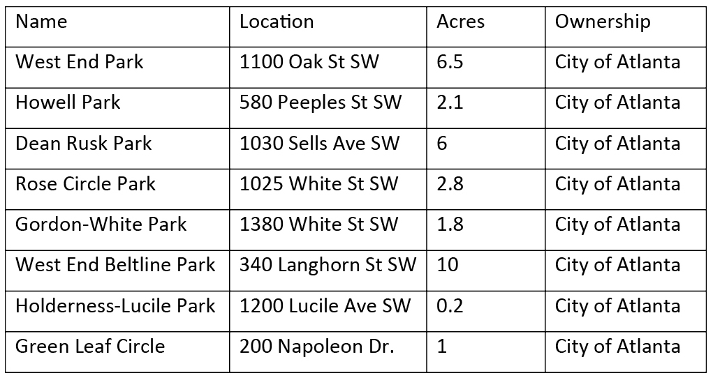
Several parks are located within the study area, however, according to a land use analysis, parks and open space comprise only 3.7% of the land coverage. The ratio of park acreage per 1,000 persons is 2.4 acres, which is less than a quarter of the City of Atlanta's goal to provide 10 acres of adequate park space per 1,000 residents. To meet the City's goal, the West End would need approximately 3.1 new acres of parkland. Notwithstanding, these parks are a strength on which to build, and could serve as an opportunity for further greenspace expansion, ecological corridor networking, and watershed management. The following map and table list the parks in the study area:
Registry of Parks Around the West End
Currently, Ralph David Abernathy Boulevard is undergoing a significant streetscape renewal process which will address many of the concern mentioned such as heat island effect, improvement of the pedestrian experience, and reduction of stormwater runoff. This project will also serve to improve the biodiversity linkage between Howell Park and Gordon-White Park. With the redevelopment plan for the Mall West End, Lee Street could serve as a similar corridor to connect a future greenspace area at the site with the green space at the Atlanta University Center.
Brownfields
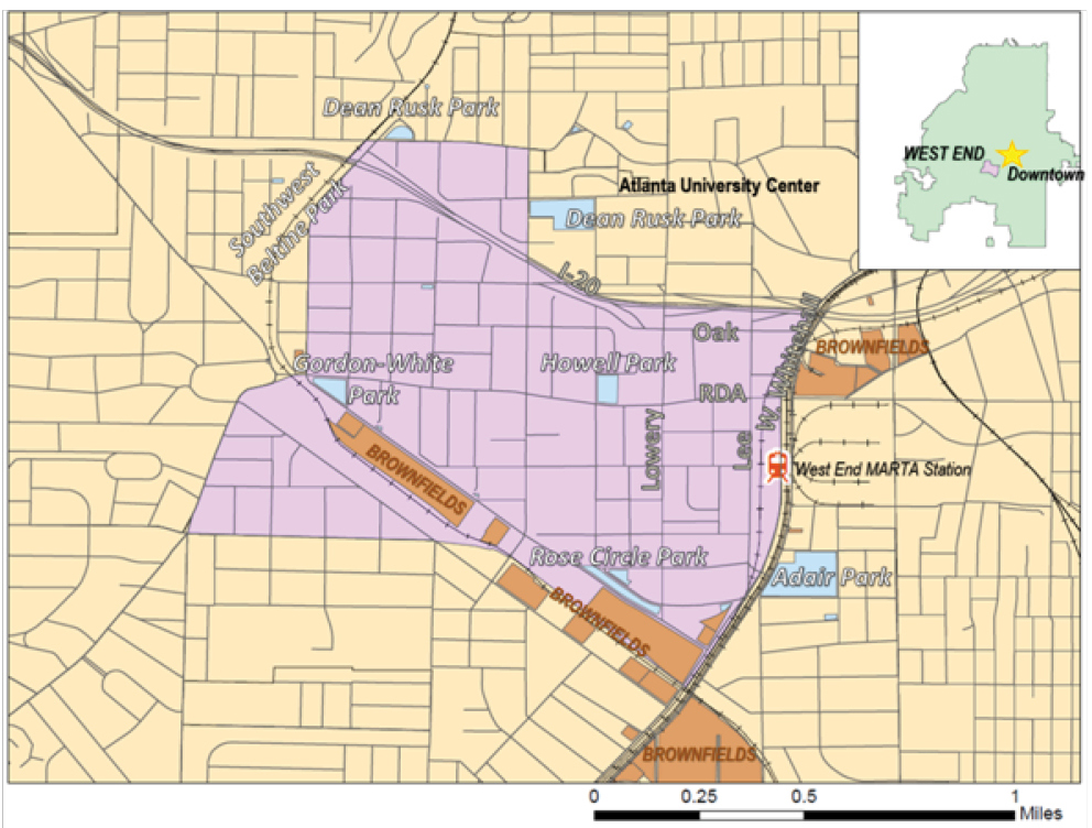
Brownfields are parcels of land that usually served an industrial purpose, either factories or warehouses, but have since been decommissioned and pose a potential threat to the environment and humans. Many brownfields require significant remediation to remove ground pollutants and other hazards to human and natural functions. Abandoned gas stations, dry cleaners, and storage facilities can also be classified as brownfields, depending on the degree of contamination to the local environment. However, brownfields have notable potential to become centers of redevelopment and revitalization if they are properly addressed. This is particularly true of brownfields that are located in close proximity to the downtown core or close to important community and transportation amenities. For these reasons, the West End brownfields could prove to be viable centers of redevelopment.
The previous map, 'Parks and Brownfields around West End,' illustrates where the brownfields are concentrated. The South and East had much industrial activity in the early twentieth century. The remaining structures are decommissioned warehouses, workshops, and other industrial facilities that used to rely on the rail line for transporting goods. The Southwest Beltline plan incorporates the renovation of brownfields to the south of the trail.
The brownfields to the east of Adair Park are more challenging to the comprehensive urban form than the brownfields to the south because they are located at the crux of Northside Drive, Metropolitan Parkway, West Whitehall Road, and Ralph David Abernathy Boulevard. This area, in its current configuration and environmental condition discourages any form of substantial investment. However, the area holds the potential to become an important gateway for the Northside Drive corridor to connect directly into the West End neighborhood. The gated, art-centric community known as 'The Metropolitan' also lies in this area, but is separated from its surrounding context with security guards and fences. Nevertheless, this community could partner with Adair Park and West End's civic engagement initiatives to bring awareness to this area.
Parks and Brownfields around West End
Public Health And Public Safety
Noise and Air Pollution
Noise pollution in the area is created by the high volume of traffic in and around the West End and is particularly problematic along the I-20 corridor, where thousands of cars consistently travel at a high rate of speed at all hours of the day. Ambient noise on the Lee Street Bridge is very high, and creates and unfriendly pedestrian environment and reduces the connectivity from the Atlanta University Center campuses and the West End. Properties in the residential neighborhoods to the west that back up to I-20 also lose property values and desirability.
Lee Street and Ralph David Abernathy Blvd. have a high volume of traffic throughout the day. Because Lee Street also serves as a freight route, the noise level from semi-trucks can be high during regular business hours. Additionally, the MARTA heavy rail line provides a source of noise throughout business hours along the North-South corridor of Lee and Whitehall Streets. Through the strategic implementation of landscape features and urban design, these problems can be mitigated, at least in part, to create a more pleasurable and secure experience for pedestrians.
The U.S. Environmental Protection Agency prescribes thresholds of specific pollutants in the air under the authority of the Clean Air Act. Fulton County is designated as a county of non-attainment according to the National Ambient Air Quality Standards (NAAQS), being high in Particulate Matter (PM), Carbon Dioxide (CO2), and Sulfur Dioxide (SO2). The West End is close to Atlanta's downtown and I-20, resulting in high air pollution levels. Though this problem must be addressed at a macro-level, heavy traffic volume of mobile-source polluters can be reduced or eliminated to improve air quality. Specifically, re-routing semi-trucks off of Lee Street would greatly reduce diesel exhaust for pedestrians. Such an initiative that would need support from crucial agencies such as the Atlanta Regional Commission and the Georgia Department of Transportation.
Health Assessment: NPU-T
Georgia Institute of Technology's Center for Geographic Information Systems (CGIS) has conducted extensive research to map specific indicators in the built environment, and their implications for public health. The information is gathered from the City of Atlanta's 2010 Census Summary Report, and is organized by NPU group. NPU-T includes the West End, Westview, and the Atlanta University Center neighborhoods. The following attributes illustrate the condition of health for the entirety of NPU-T, but can give valuable insights for the West End community (for a detailed explanation of methodology, please visit http://www.cgis.gatech.edu/nqolh/NH_Index/).
Out of 25 NPUs, NPU-T ranks 12th in the overall Neighborhood Health Ranking. Notable subcategories include ranking 6th best in access to food (low percentages are good; high percentages indicate more of the population is disconnected from healthy food), but NPU-T also comes in last in terms of morbidity (prevalence of illness) across the city, being particularly high in hypertensive heart disease (HHD). These metrics show that the West End is in the median zone relative to other neighborhoods, but certainly also show that more work can be done to improve the quality of health for the West End community, specifically in the morbidity category.
NPU-T Health Assessment Scorecard
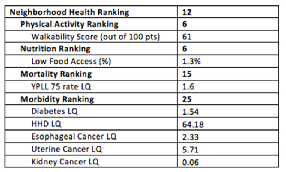
- Rankings are out of 25 Atlanta-wide NPUs.
- Walkability is defined as condition and connection of sidewalks.
- Low Food Access measured by the percent of the population without a vehicle that is over one mile from a grocery store.
- Years of Potential Life Lost (YPLL) 75 is the deviation of the population's average age of death from a 75 year life span.
- Location Quotient (LQ) of health indicators are composite scores compared city wide.
- Hypertensive Heart Disease (HHD)