West End Hub
Introduction
*This website is still a work in progress!
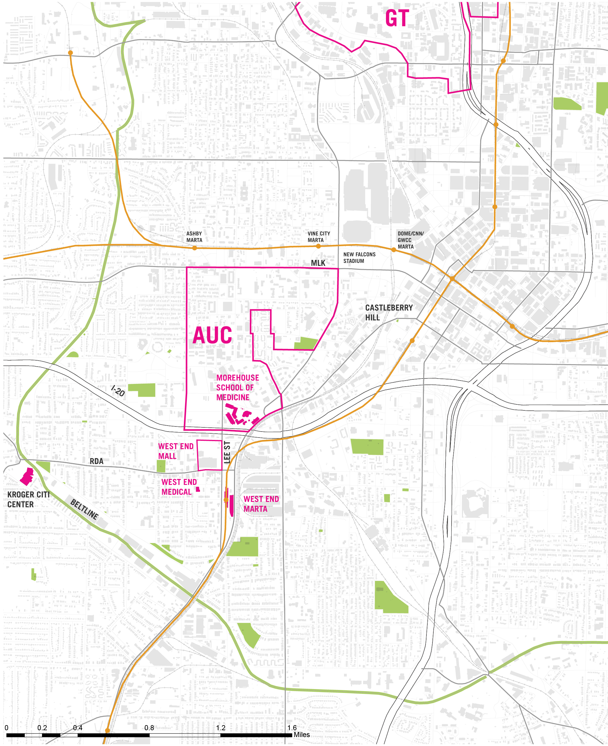
West End Context
West End Context Map
Master's Degree students in the City and Regional Planning program at Georgia Tech generated this report in the spring semester of 2014. Their purpose was to investigate the following research question: How can the economic potential of the West End to raise quality of life for its citizens be fully realized by improving transportation, land use, and the environment in the study area?
The work picked up from earlier studios that framed issues and made proposals that have begun to influence the policies and priorities for citizen groups, private sector interests, and government agencies. The first of these, www.northsidedrvision.gatech.edu, dealt with the Northside Drive corridor from I-75 to the West End. Its findings suggested that this corridor, long a dismal, utilitarian roadway, should be transformed into a grand transit boulevard, a gateway to the many strong institutions that line it and presently present a 'back alley' character. The study further identified and analyzed the racial and class divide that Northside Drive has represented for decades. It suggested ways to replace the barrier with a seam, connecting low wealth neighborhoods to the west with the jobs and amenities of Downtown and Midtown to the east, both physically and programmatically. Finally, it identified West End as the logical terminus of the Northside corridor and suggested ways to realign the southern leg of Northside Drive to accomplish that goal. In that larger context, West End becomes the southwest hub of the Midtown/ Downtown core of the City, where most of its jobs, institutions, hospitality facilities, and cultural, entertainment, and sports facilities are concentrated.
The next studio, in the fall of 2013, focused on the midpoint of the corridor, the crossroads of Northside with Martin Luther King, Jr. Drive, the principle travel corridor for neighborhoods to the west of Downtown. The studio paid special attention to the development of a new, 1.2 billion dollar stadium for the Atlanta Falcons, replacing their current home next door. The principal issues picked up on the Northside divide between rich and poor, white and black, and explored ways in which the massive new investment might benefit the neighborhoods immediately impacted. Through considerable involvement with the neighborhoods and the Atlanta University Center (AUC), the students sought to support those groups' initiatives with planning analyses and findings that could add to the pressure on the City and the Falcons to do the right thing. These included suggesting ways to improve east-west connectivity, to develop job training and employment programs for local residents, to develop procurement programs that utilized local businesses, to improve travel and utility infrastructure, and to honor the national significance of the neighborhoods' history and culture. Related to West End, the AUC, the largest concentration of historically black colleges and universities in the country, became a critical focal point, the fulcrum through which Downtown and the West End connect. And the realignment of Northside Drive underscores that relationship as the frontage travel way for both AUC and the West End, along the way providing improved access between I-20 and Downtown.
Using these works, as well as supporting data and past studies from the City, the Region, and the State, this studio explored the implications, prospects, and opportunities for West End. Through successions of meetings with neighborhood and business leaders, private sector interests, and government agencies, students prepared a framework plan that should help guide local leadership to take best advantage of the opportunities before them. The framework suggests several key features:
- +Establishing Lee Street as the key connection between the AUC, spanning the campus over I-20, to the West End business district and the MARTA rail and bus station by providing an attractive tree-lined, well lit, pedestrian environment that will then extend south to Fort McPherson and East Point
- +Reworking the AUC shuttle system to give students, faculty and staff direct and unified access to the three MARTA stations that serve their populations
- +Over time, establishing the framework provided by Lee, Ralph David Abernathy (RDA), Lowery, and Oak Streets as the vital core of the district, including incremental development and redevelopment that would modify that 'superblock' into more pedestrian-friendly subsets
- +Amplifying the already strong retail base with AUC-linked incubator, research, and other medically based activities as well as providing some level of staff and faculty housing in the broader core area
- +Realigning Northside Drive so that it flows directly into West Whitehall Street, thus overcoming the barriers of the CSX and NS rail lines, providing better access to a more efficient and less disruptive I-20 ramping system, as well as improved access to AUC, Castleberry Hill and Downtown.
Together, these moves will underscore that West End is already a transit oriented development (TOD), strengthening the growing reality that great transit and pedestrian access are keys to economic and social equity success, analogous in some ways to Georgia Tech's move across the Downtown Connector into Midtown with Tech Square. Additionally, this framework will create a clearer, more continuous linkage system that highlights West End's many parks and cultural amenities, from Adair Park, through the commercial core, to the Historic District and West End Park.
Furthermore, assuring that the area's housing policies and programs can continue to accommodate the full range of incomes and ages presently there, understanding that there are certain to be both shifts and growth in repopulating what has been a declining population, is an important component of this framework.Finally, public education policies need to also change to anticipate these shifts and growth in population.
To guide what should be an exciting future, the studio suggests that the Community Improvement District (CID) that is presently in formation, with an inclusive leadership structure, could become the 'quarterback' for many of the above initiatives. The work to be done is complicated and needs a long term, sustaining commitment to guide others' initiatives into a cohesive whole. An important first step is to identify and promote a workable makeup for the CID, ensuring that the criteria can be met. With that, efforts should be made with agencies at the City, like Invest Atlanta and the City's HUD programs, and/or foundations to support the necessary startup costs, so that the revenues generated by the CID can be applied to visible, 'no brainer' improvements to show momentum and build confidence in leadership for the future. Updating the City's Livable Centers Initiative (LCI) with the Atlanta Regional Commission is a crucial first step. The first LCI led to City land use policy and zoning moves that are entirely compatible with the above menu of initiatives. Its update could lead toward significant capital funding support that could apply to Lee Street or RDA streetscape improvements or to other community defined transportation related priorities.
The students and faculty have been appreciative of the opportunity to participate in this effort and excited by the commitment and dedication of community and AUC leaders to take this vital area to the next level.
Demographics
West End has experienced a long-term trend of population decline. While in recent years population decline has slowed somewhat from higher levels in the mid-to-late 20th Century, it has continued nonetheless. The study area for the plan saw a 21.3% decrease in overall population between 2000 and the 2008-2012 American Community Survey. The largest drops in population during this time were seen in Census Tracts 41 and 58.
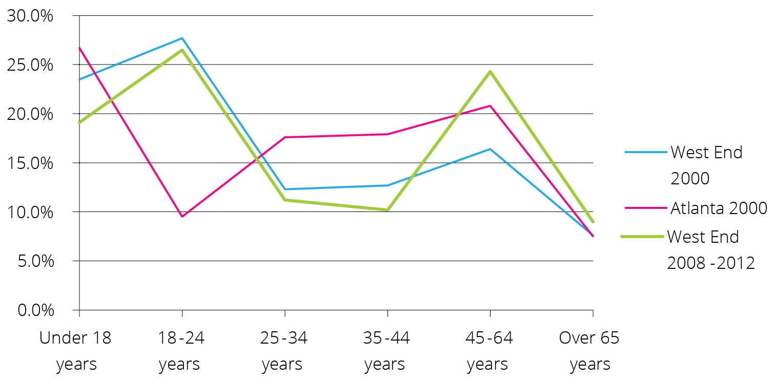
During the same time period, the area saw relative gains in residents in the older age groups. The share of residents aged 45 to 64 increased from 16.4% to 24.3%, and the share of residents aged 65 and over increased from 7.6% to 9.0%. The area maintained a disproportionately large share of residents aged 18-24; 26.5% were in this age group during the 2008 to 2012 period, much larger than the 9.3% share in the Atlanta metro area as a whole for the same time period. This age group is mainly concentrated in Census Tract 43, near the Atlanta University Center colleges. Similarly, the area has seen an increase in the relative share of nonfamily households, from 46% of all households in 2000 to 56.6% of all households in the 2008-2012 survey.
Percentage by Age Group in West End and Atlanta Metro
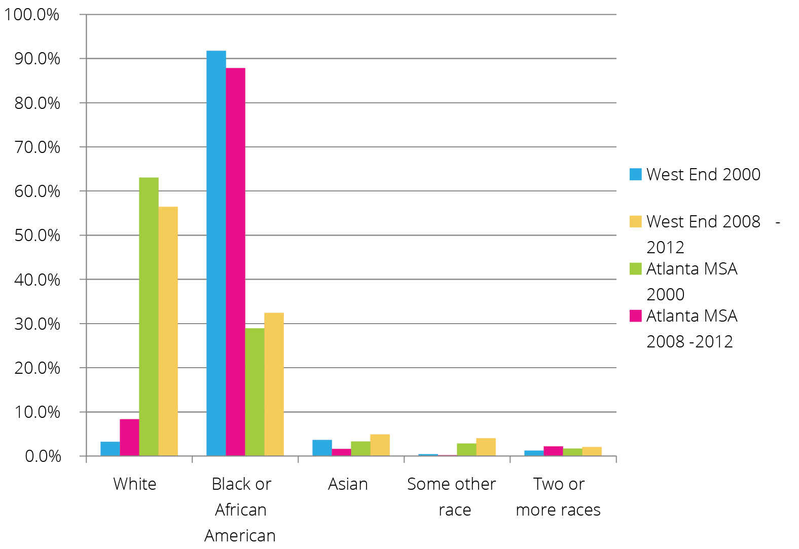
The racial makeup of the study area saw only minimal changes between 2000 and 2010. While the share of African-Americans decreased slightly during this time, this racial group still comprised the vast majority of the area's population during the 2008-2012 period, at 87.8%. The proportion of white residents increased somewhat, from 3.2% to 8.3%, and the share of Asian residents decreased slightly, from 3.6% to 1.6%.
Over the past decade, the educational attainment of the study area's residents has generally increased. 2008-2012 data shows that 22.5% of the area's residents had at least a bachelor's degree, a marked increase from 9.5% in 2000. Similarly, 80.2% of residents surveyed between 2008 and 2012 had at least a high school diploma, a significant increase from 57.9% in 2000. Most of the increase in college-educated residents occurred in Census Tracts 42 and 43, which are adjacent to the Atlanta University Center and include the West End core and Castleberry Hill areas, respectively.
Racial Makeup of West End and Atlanta Metro
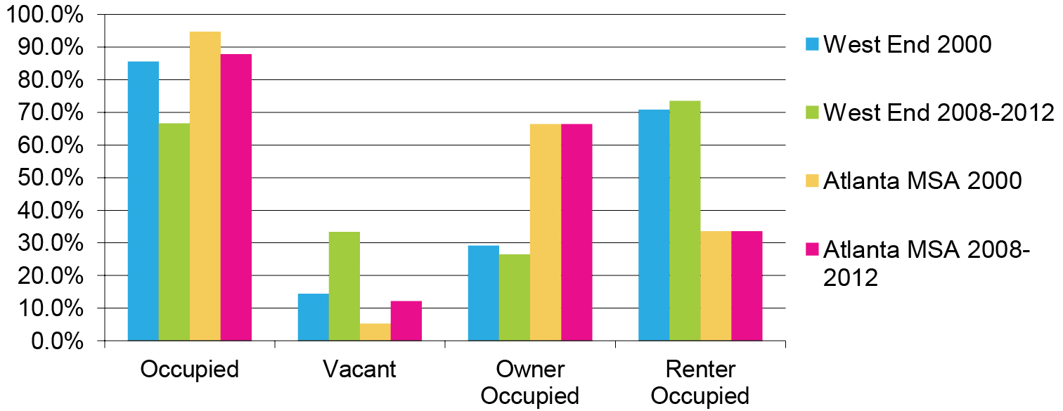
Despite a population decrease during the 2000s, the study area saw growth in housing units. Total units increased from 4,583 to 5,736, a 25.2% gain. In the absence of population growth, this led to a drop in the area's occupancy rate, from 85.6% to 66.6% during the same time period. The share of housing units that were owner-occupied fell slightly as well, from 29.2% to 26.5%. The study area has a significantly lower proportion of owner-occupiers than the Atlanta metro area as a whole, which had an owner-occupancy rate of 66.2% for the 2008-2012 period.
Vacancy and Owner-Occupancy in West End and Atlanta Metro
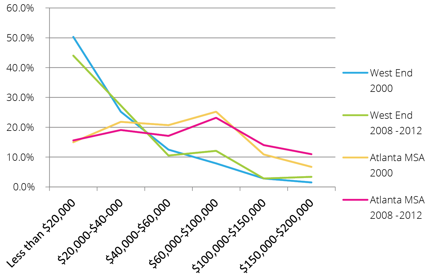
Incomes in and around the West End area also tend to be significantly lower than the metro area as a whole. Median household income and median family income in the study area for the 2008-2012 period were $22,980 and $25,980, respectively; these figures are well below the medians for the metro area ($57,470 and $67,451, respectively). Median household income and median family income increased 15.6% and 9.5% respectively between 2000 and 2010.
Property values and rents saw larger increases than incomes in the West End and surrounding neighborhoods during the 2000s. Median value of owner-occupied housing units more than doubled, from $71,016 to $147,843. This increase in median values is likely driven by new units in Census Tracts 42 and 43, respectively the core of West End and Castleberry Hill; these tracts had respective median values of $195,000 and $253,200 in the 2008-2012 survey. Median rent, while not growing as quickly as home values, significantly increased in the area as well; it rose 77.9% during the decade to $815 for the 2008-2012 period.
Vacancy and Owner-Occupancy in West End and Atlanta Metro