West End Hub
Transportation Model
*This website is still a work in progress!
Modeling the Transportation Alternatives
Introduction
In building on the prospect of a new Northside Drive connection, and providing possible alternatives to other transportation-related issues, a number of significant changes to the transportation network in and around West End are considered here as alternatives. To better analyze these alternatives, the Atlanta Regional Commission's Travel Forecasting Model for the region was used to model their traffic impacts on the road network in and around West End. The model is also being used to estimate changes in ridership expected to occur as a result of adjustments to the AUC shuttle route to and from the West End MARTA station.
Three different model scenarios were modeled: a base scenario holding the transportation system constant (except for those changes already recommended as part of all alternatives), a scenario in which the on-ramp from Lee Street to I-20 eastbound is removed, and a scenario in which the on-ramp from Lee Street to 1-20 eastbound and the off ramp from I-20 westbound to Lee Street are both removed. Changes recommended for each of these alternatives and thus coded into all model scenarios included making Oak Street two-way between Joseph Lowery Blvd. and West Whitehall Street, and reducing Lee Street to one lane in each direction between West Whitehall and the Morehouse campus, including the bridge over I-20. In addition, the proposed new Northside Drive alignment mentioned earlier is generally accepted as a preferred alternative, and as a result, it is also coded into the model scenarios for the proposed alternatives.
Methodology
To learn about the effects of the proposed alternatives and to choose the most suitable alternatives, travel demand model developed by Atlanta Regional Commission was used. Based on the proposed alternatives, the analysis was divided into two categories - Category 1 and Category 2. While Category 1 part of the solution dealt with improvements in the highway network, the Category 2 analyzed the alternatives for shuttle routes between Atlanta University center and the West End. Based on the discussions on timeline for the proposed projects, it was expected that all of the proposed changes should be over by 2028. As ARC has the input files prepared for the year 2040, this year was chosen as the year of analysis in this study. The parameters such as traffic volume, level of service on roads, transit ridership were used in evaluating these scenarios.
Category 1
Category 1 part of the solution was concentrated on the improvements in the road network. For the analysis three scenarios were compared - (1) Base or No build scenario, (2) Street improvements along with removal of a ramp from Lee street to I-20 and (3) Street improvements along with removal of both ramps on Lee street, connecting it to I-20. These three scenarios were analyzed based on the parameters of analysis. Based on comparison of the results of such analysis, a most suitable alternative for improvements in the road network was chosen.
Base
This scenario provides the base for comparison of the proposed alternatives for improvements in road network. ARC's model inputs for the year 2040 were used in this scenario. The inputs include the expected highway network for the year 2040 and the expected transit network for the year 2040 along with the projected socio-economic distribution for the year. The following figure shows the base scenario considered in this model.
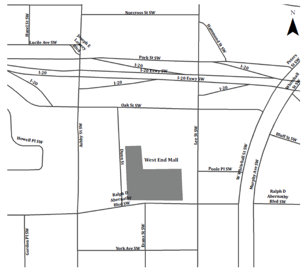
Existing Conditions
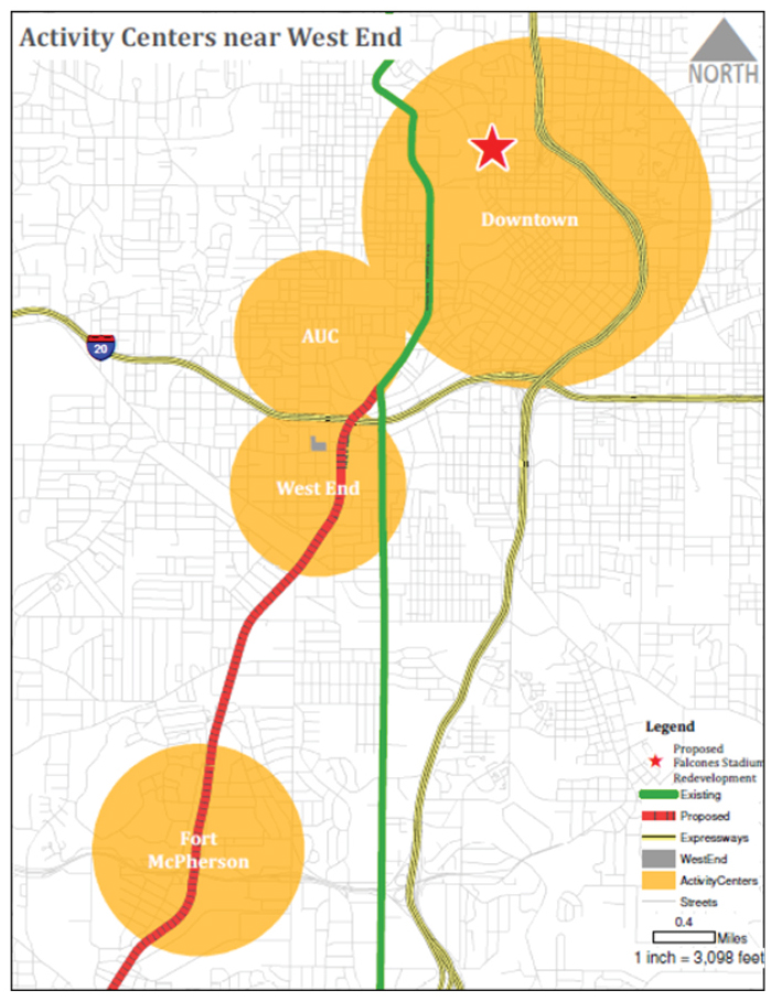
Activity Centers Around West End
Operationalizing Alternatives
After modeling the base scenario for the study, next step was to operationalize the proposed alternatives. To complete this task, ARC's 2040 highway network in Cube was updated to reflect the proposed changes in west end area.
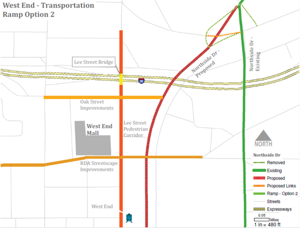
Activity Center Linkages: During analysis of the area, it was observed that the west end area's connectivity can be improved by rerouting Northside drive through the west end. The following figure shows the possibility of connectivity of west end to other activity centers through this improvement. This solution is expected to make way for west end as a future hub. For operationalizing this change, area near the triangular intersection area of Northside drive with the Metropolitan Drive and the Peter's Street was targeted. An attempt was made at realigning the Chapel Street so that Northside drive flows more naturally into the West Whitehall Street. Peter Street and the Westview drive were modified so as to reduce the number of intersections on Northside Drive. Additionally, the updated connection between West Whitehall Street and Northside Drive was updated to have lanes and its overall structure compatible with Northside Drive. Other connections between the existing Northside drive and the Peter Street were also simplified.
Oak Street: To improve the access to the west end mall area, Oak Street was observed to have an important role. Changing the existing layout of Oak Street being a one way street to make it flow in either direction might improve the flow of traffic to and from west end business district. Additionally, As, along with Ralph David Abernathy Boulevard, is one of the two major connections with Northside Drive, updating Oak Street might have stronger effect due to the realignment of Northside drive.
Ralph David Abernathy Boulevard Improvements: RDA Boulevard is the major connection between the eastern parts of the city to west end. This connection becomes more important due to the location of the area, as the metropolitan and other eastern parts are separated from west end due to the freight lines. To invite people from the eastern neighborhood, the focus was more on making the street more inviting. Having a tunnel can make it more challenging for making it attractive for pedestrians and improve a sense of security. Streetscape improvements for this street were proposed as a solution along with some safety measures and a campaign to advocate the area amidst the incoming changes. However, the travel demand model cannot take these improvements as inputs as it focuses on the more quantifiable parts of the alternatives. As a result, the model inputs did not change on account of RDA Boulevard improvements.
AUC Linkages:
Lee Street Pedestrian Corridor: As the travel demand models do not estimate the pedestrian movements, the goal of operationalizing these alternatives would be to check if the environment is conducive to a pedestrian environment. However, as the travel demand models do not consider the changes in sidewalk infrastructure and other pedestrian infrastructure, the changes were restricted to the street and bridge improvement projects. The main change in this section was to update the Lee street so that it has one lane in each direction and one turn lane on which people can turn on either side. Additionally, prohibition for heavy trucks was added on this street to make it safer for pedestrians.
Lee Street Bridge: Alternatives regarding Lee Street Bridge were mainly to make it more inviting for pedestrian movement. For this purpose the sidewalks on this bridge were proposed to be expanded. Moreover barriers such as trees were to be added on the sides so as to shield the pedestrians from the sight and noise of the I-20 the bridge crosses over and overall improve the walking experience on the bridge. For this purpose, number of lanes on the bridge was to be reduced. For operationalizing this solution, the bridge was assumed to have a lane in each direction and a turn lane in the middle.
I-20 Linkages: As identified in the problem statement, west end area seems to be separated from the AUC campus by the interstate. Additionally, Northside Drive does not seem to have a good connection with the I-20. To improve this scenario alternatives were explored.
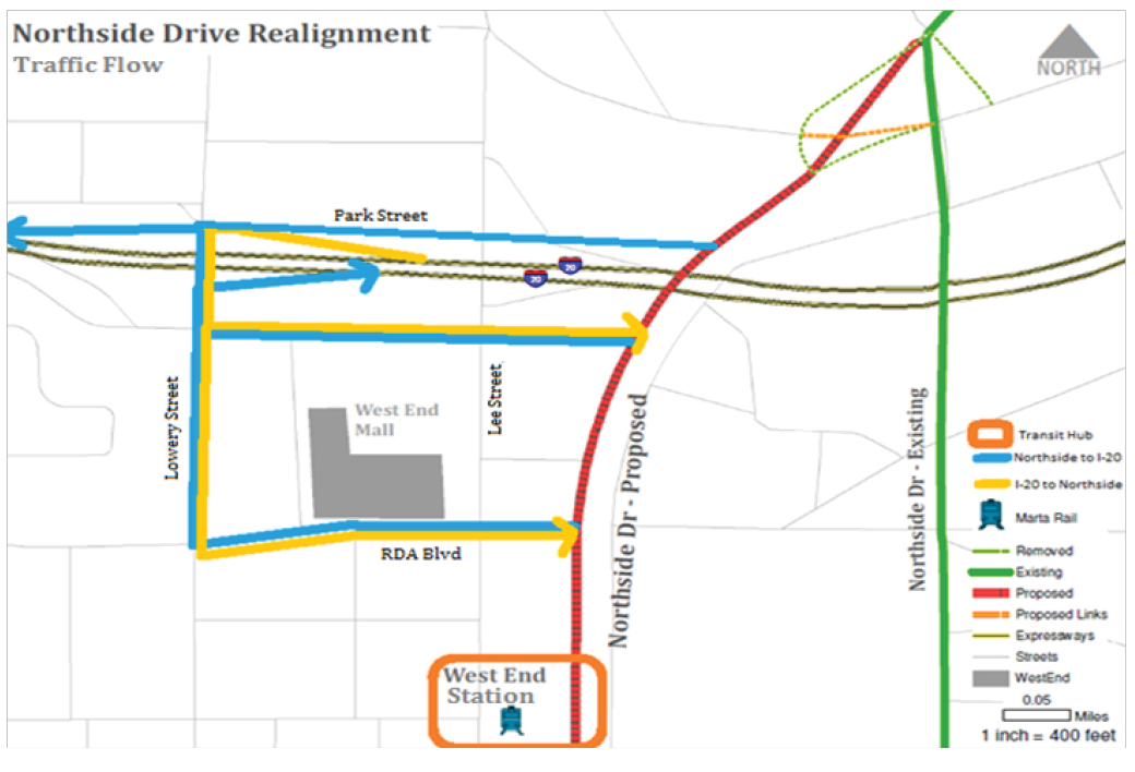
With Northside Drive: Initially, a solution to add ramps directly between I-20 and Northside Drive by replacing the existing ramps near Lee Street bridge was explored. However, upon further review problems such as weaving with the traffic on I-20 was observed. The availability of land for building such ramps might also have been an issue. Additionally, it was proposed that by providing a connection between I-20 and Northside Drive around the west end area might give exposure to the west end business district. This might end up attracting people towards west end and improve the appeal of the area. However, as this solution did not suggest any direct changes in the road network, it did not account for any updates to the ARC's highway network. Traffic between the base network and the updated network would be compared to check for this hypothesis. The following figure makes an attempt at showing the proposed Northside Drive alignment and expected traffic flows.
With west End: Currently, I-20 ramps are located near Lee Street as well as near Lowery Street. Due to industrial areas and the beltline being located to the south of west end, these ramps can transfer some heavy traffic along with trucks into the west end business district. Having heavy traffic can be detrimental to the perception of pedestrian safety on roads. As a result these ramps were not observed to be compatible with the vision of developing a pedestrian corridor between the AUC and the West End area. Having ramps so close to each other presented an opportunity to improve the pedestrian environment on Lee Street. In addition to banning trucks on Lee Street, solution scenarios such as whether to remove one or both ramps between Lee Street and I-20 were explored. Based on these two options and other road network changes the following two scenarios were modeled.
Northside Drive Realignment
Alternative 1: One Ramp
This scenario is designed to analyze an incremental approach at improving the pedestrian environment on Lee Street Corridor. It suggests the southern ramp near Lee Street to get onto I-20. Having a ramp near Lowery Street to get onto I-20, helps in making this solution feasible. This scenario also includes the updates made to Lee Street, Lee Street Bridge, Oak Street and Northside Drive. The following graphic shows the different alternatives covered in this scenario.
Scenario 1: Removing One Ramp
Alternative 2: No Ramps
This scenario is the next step in the incremental analysis for improving the pedestrian environment on Lee Street Corridor. These incremental steps provide us a way to compare these scenarios and compare their advantages as well as disadvantages. Especially due to the financial constraints associated with the transportation network upgrades, it becomes important to do such a comparative analysis and find a solution which serves our goals while saving on the resources. The second scenario suggests removing both I-20 ramps near Lee Street. It also includes updates made to Lee Street, Lee Street Bridge, Oak Street and Northside Drive. The following graphic shows the different alternatives covered in this scenario.
Scenario 2: Removing Both Ramps
Category 2 - Comparison of AUC Shuttle Routes
After analyzing the area and the existing routes, a new route for the shuttle was proposed through this studio. Apart from connecting the West End Station with AUC campus, this route also attempts to connect the MARTA Rail Stations on the northern edge of the AUC campus, namely - Ashby Station and Vine City Station. Connecting these three MARTA stations provides student with better opportunities to move around campus and connect with the city. The new route also tries to take into account the traffic flows so as to make it easier for the pedestrians to move around. This Category of analysis builds on the results of the Category 1 to compare the shuttle routes. Category 1 alternatives used the existing shuttle route between AUC and West End MARTA station. Based on the nodes on the road network, the route between AUC and West End was appropriately updated. Preferred solution from Category 1 will be the base for this comparison. Essentially, the updated route will replace the existing route in the preferred solution, while keeping the rest of the parameters unchanged. This comparative analysis will lead to selecting the most suitable AUC shuttle route to improve connectivity between AUC and West End.
Parameters of Analysis
After running the models based on the scenarios established in this section, the outputs of these models were analyzed based on the several parameters. These parameters were selected based on our goals for supporting pedestrian corridor such as - providing safer pedestrian environments, building perceptions while keeping the traffic flow in appropriate limits. The following is the list of parameters considered in this analysis.
Trip attributes: Our main goal of this studio is to help West End achieve its potential. To analyze the attainment of this goal, it becomes important to analyze the trip attributes such as trips attracted to the West End area and also the way trips have been distributed over zones from this area. Although we did not change the socio-economic composition of the west end area input files, we wanted to see the effect of the transportation infrastructure improvements on this trip attributes.
Volume: The traffic volume is an important attribute in development of a pedestrian friendly design. Having large amounts of vehicles speeding past pedestrians does not merit great amount of confidence in the mind of pedestrians about the safety of such an environment. As a result, one of the goals of the transportation improvements was to lower traffic volume on Lee Street to promote pedestrian friendly environments. Hence the results of the scenarios will also be compared on basis of the traffic volumes on street sections in this corridor.
Truck volumes: As the southern part of this area includes the industrial areas along the beltline, it becomes important to deal with the issue of truck volumes. Moving large trucks along pedestrian corridors would not be conducive to a good pedestrian environment, especially due to concerns of safety. As a result one of the goals of these projects was to curb the truck traffic in the pedestrian corridor. Measures such as prohibiting truck traffic on lee Street and ramp system improvements act in this regard. Although the truck traffic was mainly through the West Whitehall Street, as this street merges with Lee Street, it further signifies the importance of this parameter in the analysis. The outputs of the model estimate the truck counts for road segments based on types of trucks. These counts will be used in the analysis to compare the proposed scenarios.
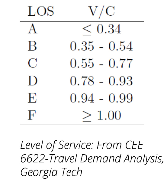
Level of service: While the alternatives such as expanding sidewalks help improve the pedestrian environment; these also result in reducing the capacity of roads. Such alternatives warrant a look at the resulting level of service for such alternatives. Even though we want to develop the areas into pedestrian friendly environments, making the traffic flow efficiently is also important in maintaining a healthy business district. Hence level of service of the road segments in the area would be used to compare the scenarios. Level of service was also compared based on the time of day, specifically in the AM and PM time periods.
Level of Service
Ridership: Ridership variable would mainly be used to compare the Atlanta university Center Shuttle routes. Based on alternatives of Category 1, the estimated ridership of the existing route in the preferred solution would be compared with the estimated ridership of the proposed route.
Vehicles Miles Traveled (VMT): Although the counts are very useful in analyzing each segment, summarizing it would not really result in meaningful results due to duplication of data. VMT would be used to understand the summary of the models to compare the proposed scenario over various geographical extents.
Vehicle Hours Traveled (VHT): VHT measures the number of hours spent on the street segment. Aggregating it over larger area provides us with a way of comparing the alternatives based on their effect on the vehicle delay.
Discussion
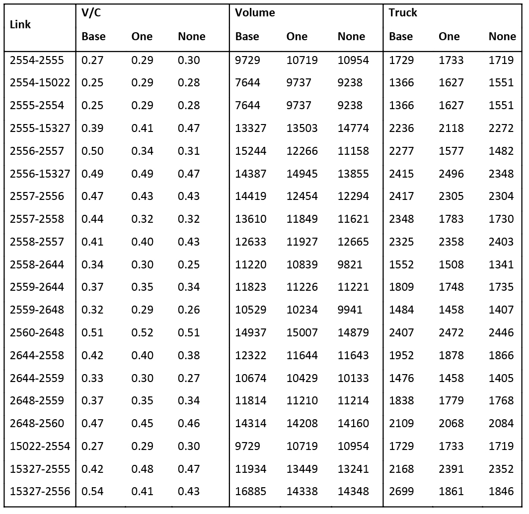
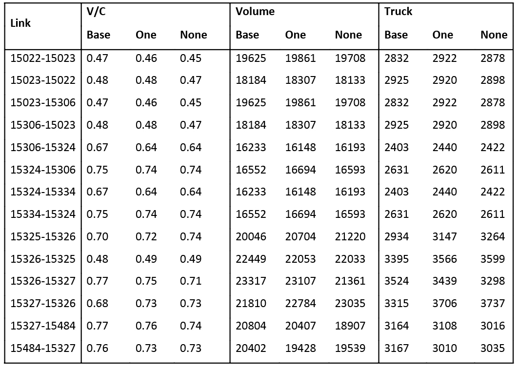
After running the Atlanta Regional Commission's travel demand model for scenarios discussed in the previous section, the results of these scenarios were compared using the set parameters. As the area consists of numerous of road segments (network links) the analysis was aggregated on corridor levels such as - (1) Lee Street, (2) Lee Street bridge, (3) Oak Street, (4) Park Street, (5) RDA Boulevard and (6) Northside Drive, to make it easier to understand. Initially, the alternatives for the area were analyzed based on trip attributes for the area. The following subsections include the comparison of results for these corridors based on the appropriate parameters.
Trips Attributes
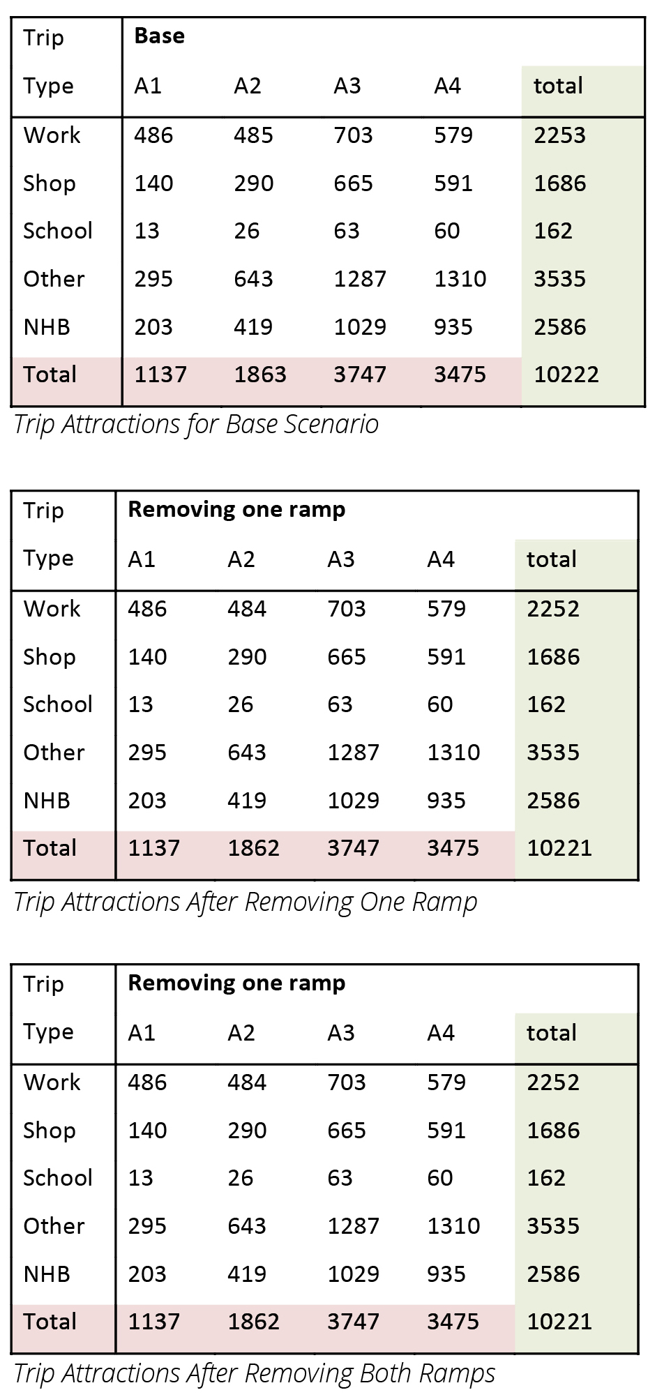
ARC's trip attraction model depends on variables such as connectivity to highways and that to transit along with employment and employment type. In this part of the model, as the only changes were made in the network input files, the effect of change in accessibility due to network upgrades would be analyzed in this section. The west end area corresponds to the TAZ 1665. The following three tables show the trips attracted towards the west end area. From the trip attraction numbers across trip types such as shopping, work based, school, non-home based or others the total trip attraction numbers seem to stay more or less the same. However, the distribution of these numbers varies depending on socio-economic strata based on the availability of cars, number of workers and their income for households. Attractions for trips without cars seem to remain the same. It was expected since the travel model does not take into account the pedestrian improvements. While the trips for category where the number of workers exceed the number of cars was observed to increase for provided alternatives. Similar trend was also observed for more cars are available than the number of workers with incomes below average. Interestingly, the attractions for higher income workers with greater availability of cars were found to decrease across various trip types. The scenario with one ramp did not experience any major change in trip attraction, while the scenario where both ramps near Lee Street were removed did experience some amount of change. As the employment characteristics are expected to be higher for the area after the proposed redevelopment, results of this comparison might end up underestimating the actual impact on the trip attractions. The results of this analysis might help in understanding the trend of change in the trip attractions due to the proposed alternatives.
Trip Attractions
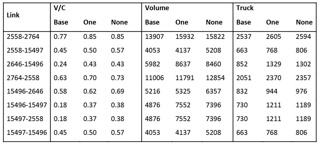
Lee Street Corridor
The possible closure of I-20 ramps, removal of lanes on Lee Street, and changes to the alignment of Northside Drive are expected to change traffic flows in the area; use of the ARC's travel demand model allows all of these changes to be modeled at once, showing their likely impacts on traffic. Based on the way alternatives were operationalized for this corridor, the performance of the scenarios was compared on the following parameters:
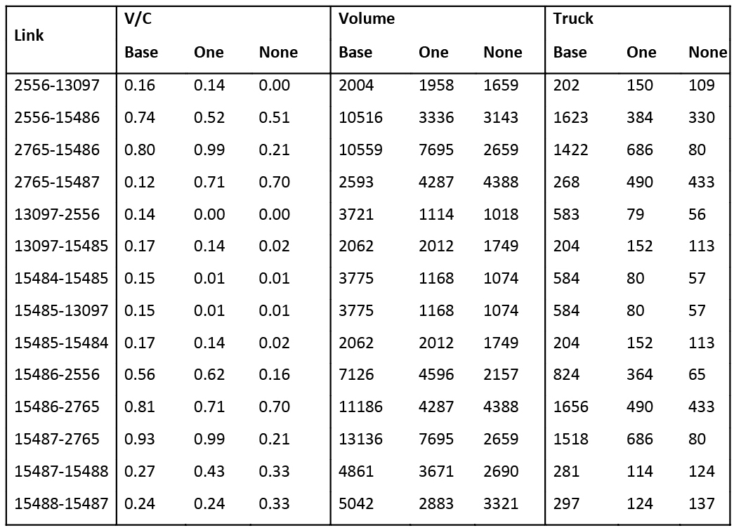
- +Volume: Most links on Lee Street observed a drop in volume when compared to the base scenario. On comparing the two proposed scenarios, it was observed that volumes on most links dropped slightly when both ramps were removed. Overall volume with ramp removal is dramatically decreased southbound on Lee Street, while volume increases somewhat in the northbound direction. Lee street segment on the bridge (going north) was a major exception here with its volume increasing with removal of ramps. As the ramps close down, some of the vehicles might be going north on Lee Street Bridge in order to get onto I-20 via Park Street.
- +Truck Volume: Truck volume observed trend similar to the overall traffic volume on this corridor. It dropped significantly with removal of ramps. As only the heavy truck traffic was prohibited from these segments, the truck volumes show the estimated traffic counts of smaller commercial trucks. Similar to the total volumes, the North-going Lee Street Bridge segment observed an increase in the truck traffic as well.
- +Level of Service: Compared to keeping both I-20 ramps, closing the southern ramp or both ramps increases volume-to-capacity ratios going northbound on Lee Street Bridge and into the Atlanta University Center, but generally decreases V/C ratios in the southbound direction. On links such as Lee Street Bridge segment going north, the level of service dropped from A to C because of the rise in volume and the lowering of its capacity due to the proposed alternatives.
Comparison of Traffic Flows on Lee St Segments
Oak Street
Closing the ramps decreases eastbound V/C ratios on Oak Street near the West End Mall, but increases the V/C ratio in the westbound direction somewhat. Total volume increases going westbound as well. On the portion of Oak Street connecting Lee Street and West Whitehall, removing both I-20 ramps decreases the eastbound V/C ratio, while removing only the ramp to I-20 east increases the eastbound V/C ratio.
Park Street
Removing one ramp increases morning V/C ratios along Park Street, while little change is seen from the base scenario in the morning when removing both ramps. Removing one ramp tends to improve V/C ratios in the afternoon, while V/C ratios in the afternoon when removing both ramps are not appreciably different from those keeping both ramps open. Overall volume along Park Street falls east of Lee Street when removing one or both ramps, while it mostly remains the same west of Lee St.
Lowery Street/Ashby Street
The opposite effects are mostly seen on the Joseph A. Lowery bridge over I-20; compared to keeping the ramps, closing them decreases volume-to-capacity ratios in the northbound direction, but increases V/C ratios in the southbound direction. Total volume with ramp removal drops by about a third in the northbound direction, and increases by about a third in the southbound direction. Southbound V/C ratios remain below 0.75 for all time periods, suggesting congestion would still not be a problem. Volume on Lowery north of I-20 remains largely unchanged.
The performance of the scenarios on Lowery Street segment near west end mall was compared on the following parameters:
- +Volume: On the link towards south, the volumes were observed to increase as the scenarios progressed, that is the highest volume was observed for solution with no ramps while lowest was observed for the base solution. While for the link going north, the volumes increased in the first solution scenario while the solution with no ramps observed a slight drop from this value for the solution with one ramp.
- +Truck Volume: Truck volumes were found to increase for the solution 1 on both directions, while an increase of lesser magnitude was observed for solution 2.
- +Level of Service: Because of the restrictions imposed on Lee Street, a lot of its traffic share seemed to have transferred onto this street segment. As a result, on the link going north the Volume by Capacity ratio of 0.77 increased to about 0.85 in the two solution scenarios. However, both of these values were in the range for level of service D (V/C in 0.77 to 0.94). Similar traits were observed in the link going south; with the difference being the level of service of this link was maintained as C throughout the three scenarios.
- +Time of Day: The AM time periods observed an increase in V/C ratio from base scenario to Solution 1, while the links observed a decrease in the ratio from Solution 1 to Solution 2 in both directions. Additionally, a drop one level of service was observed for AM periods in both directions. On the other hand, the PM time periods observed the increase of V/C ratio from base to solution 1 and then to solution 2 in both directions.
Comparison of Traffic Flow on Lowery Street Segments
Ralph David Abernathy Boulevard
Based on the way alternatives were operationalized for this corridor, the performance of the scenarios was compared on the following parameters:
- +Volume: Many links on the western section of RDA Boulevard did not experience major changes in volumes with removal of ramps. However, the ramps near west end mall and West Whitehall Street did experience major changes. Segments south of mall observed a big drop in volume in either direction. On the other hand segments near West Whitehall Street observed an increase in volume.
- +Truck Volume: Truck volumes followed a trend similar to that of the total traffic volumes with minor changes on most links, dropping volumes near the mall and increase near the West Whitehall Street Junction with removal of ramps.
- +Level of Service: RDA did not experience major changes in the level of service. Segments near West End Mall did experience improvement in level of service from B to A. Rest of the segments maintained their level of service throughout the proposed changes.
Comparison of Traffic Flow on Ralph D. Abernathy Blvd Street Segments
Effect of Northside Drive Update
Links near the intersection of Peter Street with West Whitehall Street, a rise in volume was observed. However, the segments near RDA Boulevard did experience decent change in volumes. As this change in volume occurred near Oak Street, it can be inferred that some traffic did take the connection from the West Whitehall to I-20 via Oak Street. West Whitehall Southbound segment located near Ralph David Abernathy Boulevard experienced a drop in volume with removal of ramps. However, the links going north experienced an increase in the volume. This change in volume further supports the traffic flow between I-20 and Northside Drive. Truck volumes followed the exact same trend for this street.
East of Lee Street and Oak Street, V/C ratios on the northbound portion of West Whitehall (as it becomes Northside Drive) are reduced slightly by removal of the I-20 ramps. Southbound volume-to-capacity ratios during the evening rush hour on the section of Northside Drive and West Whitehall just north of I-20 are above 1 in the base scenario, signifying congestion on these links; these V/C ratios are actually reduced somewhat by removal of the ramps, though they remain above 1.
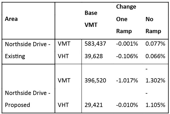
To understand the overall impact on traffic on Northside Drive after the realignment, summary traffic statistics were prepared for the two segments (table 9). For the proposed Northside Drive, only the sections up to RDA Boulevard were chosen so as to assess the performance of the proposed realignment. The aggregated statistics for the proposed segment did not particularly support our assumptions about increasing the flow to the West End area. However, this might be because of the possible redirection of traffic through Park and Oak Street towards the I-20. Conceptually, the I-20 was expected to increase connectivity with I-20, it might have resulted in decreasing the traffic in sections after the links with I-20 and resulted in an overall decrease. This decrease was sharper in case of the second scenario when both ramps were removed. As the connectivity with I-20 is relatively better in scenario 1 because of the presence of one of the ramps, it was expected that the second scenario should counter the effect of reduction in traffic on the proposed Northside Drive. Although it is not clear from the observation if realigning Northside Drive is indeed attracting more people to West End, especially as the traffic on Northside Drive seems to be dropping as the connectivity to I-20 is worsened, we need to take into account the fact that the changing land use has not been taken into account while running the travel demand model. As the structure and composition of West End are changes in future, trip attractions to the area will change as well.
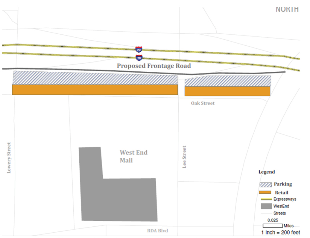
To study this issue further, we would need to run a scenario with the existing setup of transportation network, with only change being the realignment. This would give us an opportunity to study the effects of the realignment irrespective of other proposed alternatives about west end. This issue prompted us to look at another alternative, basically to look into ways of improving connectivity of Northside Drive to I-20, while trying to keep the pedestrian environment intact. Through this alternative, we would like to explore the possibility of adding a frontage road between Oak Street and I-20. As this road would connect Northside Drive with I-20 ramps, overall connectivity of Northside Drive with i-20 might increase, while shielding Oak Street from increased traffic. This might help maintain pedestrian friendly environment in West End. To improve pedestrian environment in this area even further, parking for retail stores on Oak Street can be moved towards Frontage road, while moving stores nearer Oak Street.
Improving Northside Drive - I20 Connection by Adding a Frontage Road Between I-20 and Oak Street
Comparison of Traffic Flow on Northside Drive Street Segments
Summary Comparison of Northside Drive Realignment
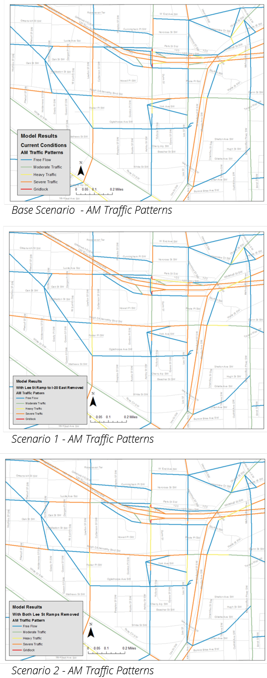
Model: Morning Pattern
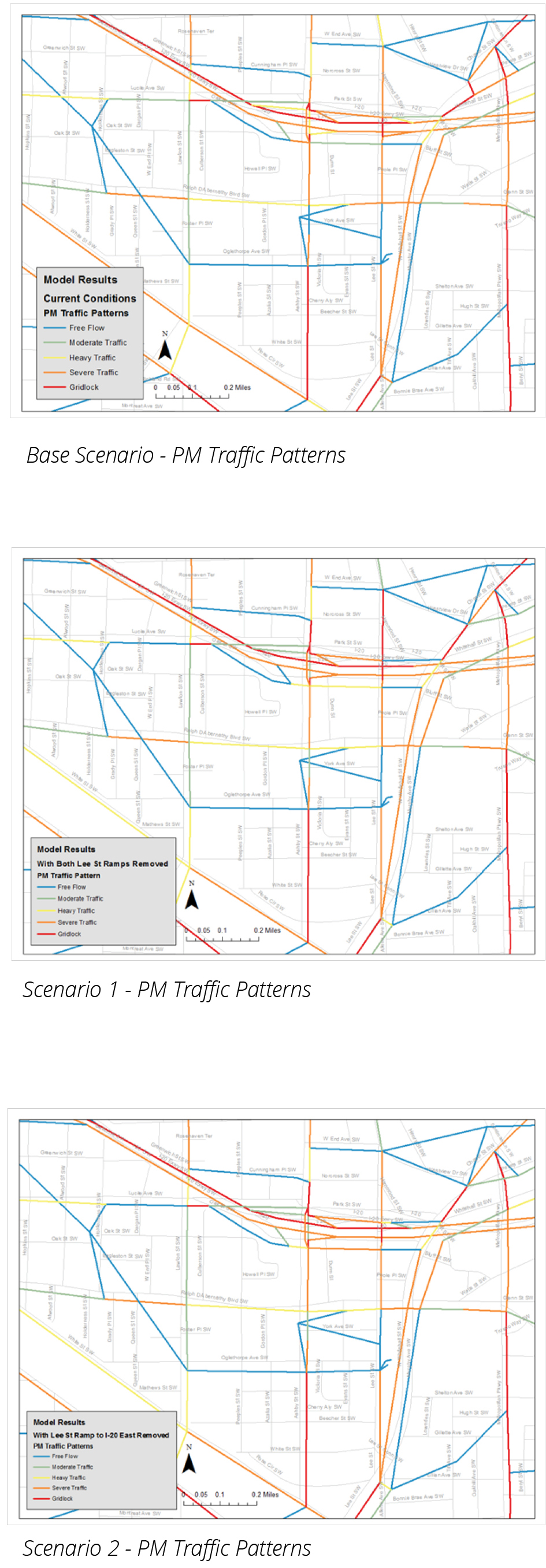
Model: Evening Patterns
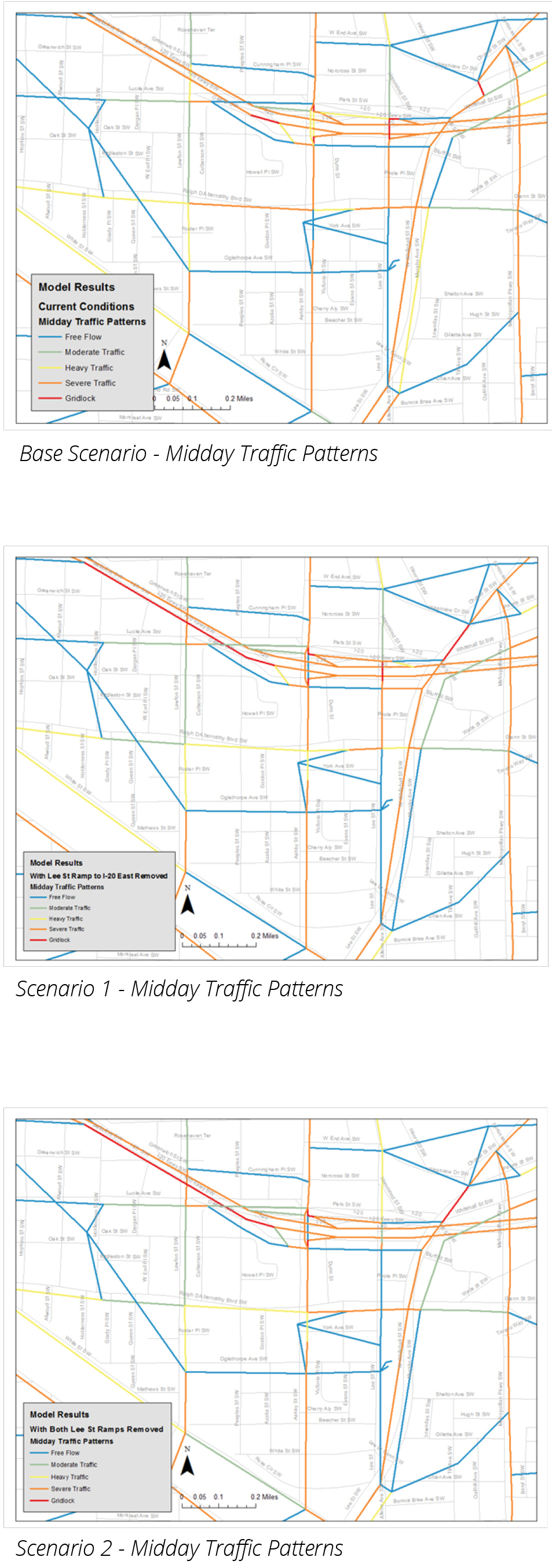
Model: Midday Pattern
Choosing the Alternative
Summary Comparison of Solution Scenarios
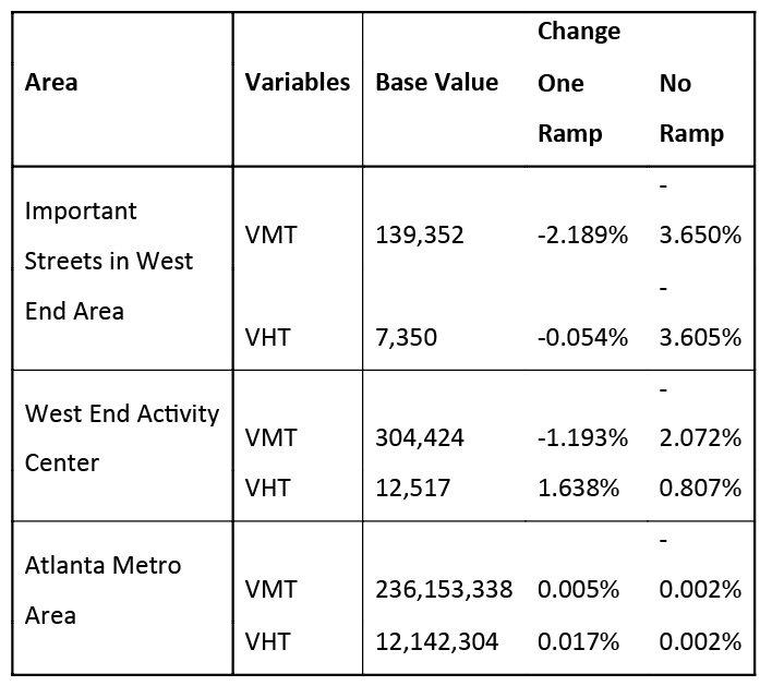
Both of the proposed alternatives ended up reducing the traffic on the pedestrian corridors. These alternatives were also successful in decreasing the truck traffic volume on the pedestrian focused areas near West End mall. Removing both ramps seemed to have a greater impact on traffic estimation in such road segments. The proposed alternatives for managing the supply of road network also affected the level of service on road segments in the area. In the pedestrian corridor, removing ramps resulted in better
Rerouting AUC Shuttle: To get an idea about how rerouting AUC shuttle affects ridership levels, another model was run by adding the new route to the preferred scenario - removing both ramps near Lee Street. Upon their comparison, it was found that the model estimated a 25% rise in ridership after rerouting the shuttle. Before concluding about advantages of the proposed solution, it becomes important to look at the assumption of the model. ARC's travel demand model does not differentiate between usual zones and university specific areas. As a result, the model considers AUC shuttle as just another transit alternative and allocates riders to it. This effect is further amplified by the area being dense and high transit use area. These factors along with lower fares for university shuttle result in higher number of riders on these routes. As a result, we need to be careful about interpreting ridership estimates. However, as these conditions are same for both route options, we might be able to get a general idea about the trend in which ridership might go. Hence, we think that rerouting AUC shuttle to West End might help in improving connectivity of West End to AUC campus.
Conclusions
Vastness of outputs generated by the travel demand modeling process suggests that further study of these results might suggest some other interesting alternatives for improving the area. While interpreting the results of travel demand models, we also need to be careful about assumptions that go into it. The major part of these alternatives was an attempt at creating a pedestrian friendly environment in West End so as to help the area in achieving its economic potential. However, travel demand models generally do not model the flow of pedestrians. As a result, we would not be able to directly analyze the impacts of improvements in pedestrian infrastructure.
To conclude, we believe that making changes in transportation infrastructure at West End might make it more pedestrian friendly. Model results support the hypothesis about the way traffic flow would change in the area. These changes were most visible in Lee Street corridor. After analyzing the ramping system alternatives, removing both ramps - connecting I20-E with Park Street and I20-W with Oak Street, might be a preferable solution to make Lee Street a pedestrian corridor. Simplified AUC shuttle route was estimated to pull in more riders than the existing route.
Realigning Northside Drive so that it flows more naturally into West End might provide a better connection between Northside Drive and I-20. It might bring in more traffic on to Oak Street and Park Street, while seeking a connection to I-20. Adding a frontage road between Oak Street and I-20 might help address this problem, while providing a more direct access between I-20 and Northside Drive.